
Unlocking the secret history of a 272-year-old mystery on the shores of Lake Erie
Author: Joe Boroi
Images: Joe Boroi (unless otherwise noted)
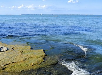
As a young boy, my brothers and I sailed the Portage River and Sandusky Bay in northern Ohio seeking adventure and discovery. Years later, I would learn that the first man to document the size and scope of these waterways in his journal was a French Military Officer. After carefully studying his route, I was shocked to realize that the actual portage trail his expedition likely followed from the bay to Lake Erie crossed through the yard where we lived as kids. When I took the time to learn more about Gaspard-Joseph Chaussegros de Léry, it was my own understanding of the bay and terrain in and around Port Clinton, Ohio that would lead me to a new interpretation of his journal and the significance of a French Fort shrouded in mystery for 272 years.
The War Path
In the middle of the 18th Century, both Britain and France lay claim to the Ohio Country. Northwest of the Ohio River, it was a land that was fertile, rugged, and filled with promise. It captured the imagination of Europeans who saw it as rich in natural resources and beauty. Its rivers were navigable and Native Americans had a well established network of trade routes over land that extended from the east coast to the Gulf. The northern boundary of Ohio Country was drawn by the Great Lakes which separated the region from other land claims of New France. When weather permitted, these lakes were navigated by canoe. Storms were known to make paddling these massive bodies of water difficult. In the winter, they were blocked by ice flows. Conditions for travel also limited military expeditions, re-supply, and slowed European settlement migration in the region over the first few centuries of colonization in the Americas.
For many, the Ohio Country seemed off limits to settlement, unforgiving, and treacherous. In the 1700s, there was a bloody proxy war bubbling up from the rivers, lakes, and streams of The Ohio. The French, British, and Spanish authorities used various Native American Alliances to disrupt settlement and trade. Long before Europeans arrived, the native people of Ohio had been engaged in a long 100-year civil war seeking to control key hunting tracks and fishing grounds across present day Ohio, Indiana, Illinois, and Michigan. Along the shores of Lake Erie, the aftermath of this civil war continued to threaten French defensive positions near present day Detroit with a fury of activity that stretched east toward the present-day Sandusky Bay. At the time, the French considered this bay to be a lake which they named Lake Dotsandoske.
By the mid-1700s, British emissaries from Pennsylvania and Virginia Colonies had effectively de-stabilized the region with propaganda designed around empty promises and relentless fear mongering. Ongoing attacks on traders, settlers, and native villages terrorized the region making it difficult to expand existing settlements and land claims.
For almost nine years, French traders living in and around Fort Detroit were terrorized by a War Chief named Nicolas. In 1739, Sieur De Noyelle at Fort Detroit wrote in a memo to Marquis De Beauharnais, “The Hurons all gathered at Sandoske, although they had been told that they have nothing to fear.” “They were armed like men who go to fight – bullets in their mouths and in their guns and one Nicolas was their Chief.” “As I fear, lest he may hatch something wrong.” Reports like this and attacks on French Traders continue for years until Nicolas loses his alliance and other Native Tribes refuse to back his campaign of terror in the region. By 1748, it is the British that the Sieur De Noyelle is now concerned about. In the same year that Nicolas and his tribe flee the region he writes, “The conduct of Nicolas is suspicious, the English from Philadelphia came there (Sandoske) twice this winter and were well received.”
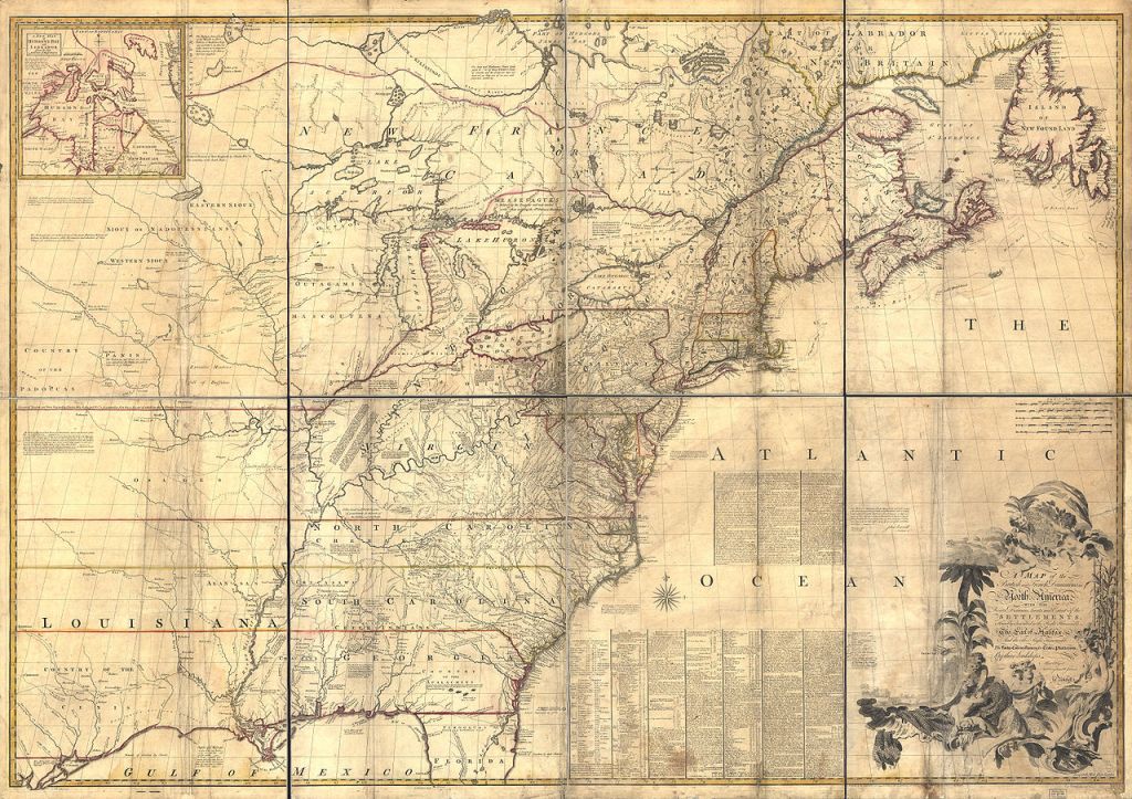
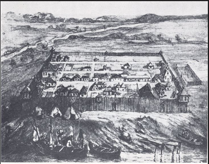
We learn some years later in 1750 from Christopher Gist, the land surveyor for “The Ohio Company”, which the British have established to push settlement in the region, that the French are building a Fort at Sandoske, “Two Traders belonging to Mr. Croghan came into town and informed us that two of his people had been taken up by 40 Frenchman and 20 Indians who carried them with 4 loads of skins to a new fort the French were building on the branches of Lake Erie. Around this same time period, there is a Map known as the “Mitchell Map” which appears showing a French Fort on the North Side of the bay “Usurped by the French” suggesting that Sieur De Noyelle had the Pennsylvania Traders he writes about in 1748 removed by force from the area. Assuming this is true, he then had a Fort built north of the bay that John Defever described in 1752, “… made of picket, no canon. Not Above 15 rods square.”
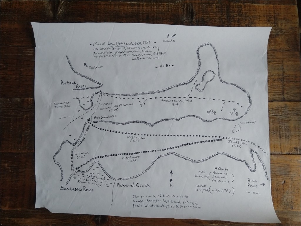
In 1908, Lucy Elliot Keeler finally sheds some light on French activity along Lake Erie and the Sandusky Bay in northern Ohio. She published her research entitled “Old Fort Sandoske” which combined a Journal and drawings from a 1754-1755 French Military Expedition with other historical records about later British, Indian, and American military activity in and around the Bay region. That journal, written by a French Officer named de Léry, is now the key record we have indicating that there was a French Fort North of Sandusky Bay near present day Port Clinton, Ohio. Charles Frohman, a Sandusky, Ohio based historian, re-analyzed Keeler’s research by combining what we know about the geographic surveys, geology and archaeology of Sandusky Bay in his Spring 1976 Article, “Searching for the Forts and Indian Villages of Sandusky Bay.” Keeler and Frohman’s work establishes the historical narrative that there was a British trader’s residence built in 1748 (or earlier) which was then officially fortified by the French in or around 1750. Fort Sandoske is probably the oldest French Fort inside the present-day state of Ohio, however, its exact location has remained a mystery for 272 years. We know from De Lery’s Journal that the fort was constructed only a few yards from the portage trail and 30 feet from the bay. If you know which portage trail the French used, then you know where the fort is. For a number of reasons, this small detail has been difficult to prove.
The Gypsum Conspiracy
I almost immediately assumed that the portage road must be east of Fulton Street toward the old Gypsum mines. The Toledo Blade reported in the early 2000s that an Indian settlement was discovered on the north side of the bay near the current bridge. Artifacts at this settlement suggest that there was trade with the Gulf Coast going back some 1000 years. There is an old road that cuts across the peninsula from the the lake to the bay that was used by miners dating back to the mid 1800s. This mining road doesn’t seem to show up on earlier military surveys of the Indian trails, but, by the 18th century, the Indian settlement north of the bay was long gone. It seems possible that those who mined Gypsum might have done so along an old Indian Trail. They may have even uncovered an old Indian mine. 19th century military surveys also suggest that the French planted orchards on the far side of the peninsula near present day Marblehead. These Orchards could indicate that there was French activity east of Port Clinton.
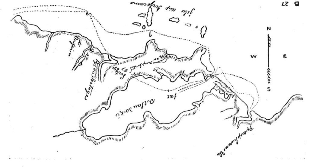
Historians would point out that Gypsum wasn’t discovered until the 1820s in Port Clinton. It’s easy to argue that historians might have this wrong. Gypsum was very important to Native Americans and would have been one of the things that made trade all the way to the Gulf Coast economically and politically viable. Gypsum was also widely used and well known by the French who mined it themselves back home. However, it was mostly mined by farmers and traded as a fertilizer in the new world. De Lery’s father-in-law controlled land in an area that mined Gypsum. De Lery’s engineering background may have given him some knowledge of the material. Perhaps the French knew that Gypsum could be mined in Port Clinton and this was a much larger and more strategic reason for a fort East of town. De Lery’s own sketch of the bay seems to place the portage route southeast of the Portage River. Could he have followed a dry trail to Lake Erie just east of the Portage River instead of using the wet swampy trails to the west? He does describe seeing the islands from the shore line in a later entry. It also makes sense that the French might have wanted to keep the potential resources on the peninsula a secret. This could help explain why Gypsum on the peninsula prior to the 19th century was not a part of the historical record. However, other than De Lery’s sketch and known Indian Settlements from an earlier era, there is very little evidence today that supports a south eastern Portage Trail on the north side of the bay that aligns with the mining trail we know about today. His compass direction and all of the other measurements he takes seem to indicate that it is very unlikely the Gyspum mine trail east of Fulton Street was used. A year later his journal will provide us clues as to why this sketch seems inaccurate. One thing is for sure, De Lery’s notes and sketches have certainly confused researchers for the last 100 years.
The Fulton Street Theory
Lucy Elliot Keeler’s article features a map with the fort and portage marked but she does not credit this map to a source. It is clear by the location mapped by Keeler that she believed the fort to be at the end of present-day Fulton Street. Perhaps due to erosion, Frohman later theorizes, any archaeological evidence of this is now lost below the surface of the bay. De Lery’s journal even provides us a distance from the entrance of the bay to the edge of Fulton Street. The distance De Lery provides of the portage also matches up with the length of Fulton Street. For more than 100 years, historians have echoed this location over and over in every official narrative of Fort Sandoske. There is even a marker at the end of Fulton describing the fort.
Fulton is the only street near the mouth of the Portage River that connects Lake Erie with the Bay making it the obvious choice to look for an old portage road. However, it would seem a bit odd that a previous route along Fulton fitting so neatly into the grid of present-day Port Clinton would be all that old. The town of Port Clinton itself wasn’t established until 1828 which is 73 years after De Lery described the portage trail in his journal. Fulton also runs north and south on a longitudinal line. The French traveled the Great Lakes in canoes. It seems very unlikely that their officers would have carried the heavy and expensive equipment needed to mark and survey a road based on its longitudinal position. Instead, the French would have simply adopted older trails used by Native Americans for centuries to trade throughout the region. The trail that the French would have discovered connecting the Bay with the Portage River would have been hundreds of years old. It is far more likely that the Native American’s trade route would have followed the contour of the land at more of an angle toward the Sandusky River. It’s difficult to study the land in and around Port Clinton because it changed drastically in the 19th century when the State of Ohio ordered the draining of the Black Swamp. It is more likely that a straight north and south portage on Fulton street (if one existed) was established much later. In fact, it looks exactly like the sort of road that the Americans would have used to portage heavier goods during the War of 1812. They would have needed to carry larger equipment to boats supporting their forts and encampments further south within the Ohio region.
If the exact location of Fort Sandoske along the portage trail in Port Clinton, Ohio is not near Fulton Street as historians thought for decades, then, we truly have a 272-year old mystery that Lt Chaussegros De Lery’s hid in his journal very well. It is entirely likely that the remains of this archeological treasure are lost below the waters of the present-day Sandusky Bay because of how closely the fort was built to the shore. The Fort’s discovery or archeological evidence proving its existence may be difficult to obtain. Concrete proof that could be dated to the 1750s would settle the mystery once and for all. For now, we must re-evaluate the primary documents associated with this fort to understand if Fulton Street is indeed the old portage road the French used during their expedition to Detroit.
It was a message. The first of its kind. A message that sparked a war.
Sandoske was ignored or forgotten by main stream historians because no decisive battle or event took place at the Fort. De Lery himself describes it as abandoned. Yet, Sandoske was the first fort ever built in the State of Ohio. Its construction and garrison sent a message to Native Americans and British Settlers that the French claimed Northern Ohio for New France. The very existence of Sandoske likely sparked a fury of activity among British and American colonists hopeful that they might counter the French foothold in the Ohio. The symbolism of this Fort and the events it triggered in the years to come make it a catalyst for what would unfold across the continent in the decades after it was constructed. Fort Sandoske wasn’t just an abandoned garrison. It was a message. The first of its kind. A message that sparked a war.

Lt Chaussegros De Lery’s journal holds the key to the Fort’s location. Historians have looked at his notes and they have mapped distances based on how he describes the start and finish of a leg in his journey. To decode the actual map that triangulates a position for Fort Sandoske, one must first understand De Lery himself. His personality, methods, and state of mind are critical to decoding the journal entries he makes.
Decoding The Journal
Who was Joseph De Lery? He was an engineer, soldier, public servant, explorer, and an entrepreneur living in a time of endless possibility and shifting loyalties. Born 20 July 1721 in Quebec, he was 33 during a military expedition to Fort Detroit that he documents in his journal. From Keeler we learn that he first attended Jesuit school as was typical for boys his age. He was the son of a French Engineer and well trained by his father. At 11, he was a child prodigy already applying for engineering positions in Quebec. Without much luck getting other members of his chosen profession to take a boy of his age seriously, he continued schooling at Minor Seminary and Jesuits College until he was 18. In 1739, he received a distinguished role as assistant engineer. His ambition eventually leads him toward a military commission. He spends time in Louisiana where he begins to apply his knowledge of engineering to fortification and route clearing.
He satisfied his leaders who continue to give him more responsibilities. Throughout his twenties we see him complete several reconnaissance operations that prove his ability to translate or exploit the engineering skills he picked up as a young boy into military intelligence acumen. He becomes the first person to navigate the Ohio River by compass. He commands an artillery unit and is promoted to lieutenant in 1751. He commands Fort Beavsjour and Gaspareow. In 1752, he is sent to the military maneuver school in La Rachelle. He marries Louise Martel De Brovajue in 1754, the daughter of a wealthy landowner and businessman in Quebec. This nuptial further solidifies his long-term status in Quebec’s social and political ranks. The next few years at Niagara, Detroit, and Duquesne are busy ones for De Lery as he continues to provide reconnoiter, supply, and fortification support to key French installations.
De Lery was eventually promoted to Captain in 1757 after he successfully led a party of 360 Indians, Canadians, and French Regulars through difficult wooded terrain and bad weather to destroy the supply depot at Fort Bull east of Oneida Lake, NY. From here, we see him playing a series of diplomatic and support roles until he is eventually wounded and captured at the Battle of the Plains of Abraham. He was awarded the Cross of St Louis in 1759 and his family then sent to France in 1761. At this time, it was clear to him that France was losing its grip on the Americas, so he hatches a plan to ensure his sons are schooled in France, then takes part in a delegation of French Officers that are presented to King William III. He lives out the rest of his life in politics and business placating to the change in power of French to British authorities in Canada. He fastens his life to self-interest but continues his public service until his death in December of 1797 at the age of 76.

From the diary of Joseph De Lery, we find a man who is as ambitious as he is restless. His diaries were private and not made public until after his death. He begins his journal in April of 1754 with a voyage by canoe out of Quebec. By the end of April, he has departed Montreal for Niagara and then moves on to Presque Isle. His name appears on a command list for Belle Riviere (Ohio River) Operations which he would much prefer over his current orders to Fort Detroit for a year of fort maintenance.
23 April “I asked the general his reason for placing me on the list for Belle Riviere, and explained why I preferred this campaign to being in Garrison at Detroit. He told me that my destination had not changed and he would give me more orders.”
From the Diaries of Gaspard-Joseph Chaussegros de Léry
From this journal excerpt we learn that De Lery recognizes that orders to the Belle Riviere are more promising for his career aspirations. There he would find himself on the front lines defending French interests from British encroachment. De Lery knows that a year on the far reaches of New France spent in a support role, maintaining an old fort, had far less potential for moving his career forward. This mindset is an important factor in how he behaves on the expedition. He accepts his fate but looks for any opportunity that he can use to make the most of it. As the expedition continues forward, we will find De Lery excited to map the unknown.
According to De Lery’s journal, the expedition from Presque Isle to Detroit included 27 canoes and 285 men. Each canoe is packed down with rations, supplies, and trade goods. To make the most of his supporting role on the expedition, we find De Lery capturing a pace count early on for his canoe. He measures strokes per minute and averages them out for weather conditions and fatigue throughout the day. De Lery is also known for taking azimuths and noting key terrain features like the mouth of a river or the start and stop of various cliffs above the shore line. It becomes clear from his notes that tracking pace count is creating some efficiency for his boat. Each day, his crew passes other boats while staying consistent in their timing and movement despite the wind and waves on Lake Erie. De Lery uses the analytics he gathered about his crew’s paddling to demand consistency.
His canoe continues to pass other boats and even moves ahead of senior officers on the expedition. It becomes clear from his journal entries that the consistency, time tracking, and terrain notations serve a larger purpose. De Lery is making a map. Not only is he creating a map, but he is focused mostly on the Sandusky Bay. As it turns out, the portage route through the Sandusky Bay had never been properly mapped by previous expeditions. De Lery, would be the first to fully document the size and scale of this waterway in the new world.
By the time we find De Lery at the portage in Sandoske documenting the abandoned Fort near the shore, he is almost 2 hours ahead of the expedition. He uses his time near present day Port Clinton efficiently to sketch the fort and take its dimensions. Earlier that day, he had recruited the chaplain to take a measurement from the mouth of the river. The chaplain’s measurement of Latitude on the west side of the Black River near present day Lorain, Ohio is critical. With this measurement noted in his journal, De Lery brilliantly allows us to calculate an exact longitude years later. He likely understood that a position of latitude along Lake Erie’s shoreline dipping south could later map to a more precise point on a grid. For more than 100 years, historians focused too closely on individual distances, headings, and notes. The secret of De Lery’s map only reveals itself when all the numbers and azimuths are combined.

In fact, the numbers he gathers on his return trip one year later actually help to tie his map together. When they reached the portage trail in 1754, the expedition would continue northwest toward Fort Detroit. When De Lery returns in 1755, he maps the distance from the portage trail to the mouth of the Sandusky River and then connects that location to his other line from the year before, closer to the mouth of the bay.
When you start in Lorain and map De Lery’s path to the Sandusky Bay, there is a much more accurate picture that emerges. Instead of Fulton Street, we find the Portage Trail and fort much farther west. When you layer military surveys of trails in the area (used continuously by natives, British, French, and American forces) to De Lery’s map, you find a trail that starts in the northwest corner of the bay. This trail heads north toward the present-day Portage Park in Port Clinton and then north east toward the Portage River and Lake Erie at the azimuth De Lery provides in his journal. Almost 272 years later, we now know where Fort Sandoske is thanks to De Lery and his careful map making skills. Against all odds, he creates an incredible picture for us of the bay. This is a fort where no documented battle of significance took place, yet, its importance should not be underestimated. Fort Sandoske was the first fort built in the State of Ohio. It has been lost for so long because at first glance it seems rather insignificant in the grand scheme of events that would play out between French, British, American, and native populations in the years to come. The original Fort Sandoske in present day Port Clinton was an installation that was built to send a message. We see that message echo across the Ohio Country as British Traders get word of it along the waterways that stretch across the region. One could easily argue that this fort was a catalyst of the French and Indian War, or at the very least it’s abandonment as a symbol of France’s fading grip of its claim over New France.
Mapping The Truth
In the end, the primary documents related to Fort Sandoske have been difficult to research over the last 100 plus years. Many of them are located in Quebec or France. Most of them also require translation. As more documents are digitized and made accessible to researchers, we may find it easier to re-assess what scholars think they know about French military operations in the Ohio Country. There isn’t much evidence today proving that the French may have known about mineral or rock deposits in Sandoske country but it’s worth exploring the possibility that ancient Indian tribes did.
Instead of a trail east of Fulton near the rock deposits, it may be more plausible to explain De Lery’s sketch by assuming that the mouth of the Portage river was slightly northwest of where it is today. One could also assume that a branch of the trail went northwest in addition to northeast. De Lery’s sketch that shows a northwest route was done in the first trip and doesn’t include all of his measurements and follow ups. We find him in the return trip noting in his journal that things look different in the spring and are a bit more wet. He also points out in his journal the fact that sometimes he went back later to add numbers or notes but didn’t always change every aspect of his journal to reflect the tweak.
Based on De Lery’s engineering background and the way he captures his numbers, I think it’s safe to assume that the distances, azimuths, and latitudes are what he wanted to accurately capture. This is evident in how they reveal themselves so incredibly when mapped today. In Port Clinton as we know it now, we find a road called Portage Road north of the military survey routes. This road looks more like his sketch that oddly contradicts his measurements if you assume that the mouth of the river shifted slightly. The old Insurance maps from 19th century Port Clinton confirm that this area was swampy and perhaps not used by later forces, which is how a northwest route to the west of Fulton street could have fallen off of military surveys done in the 19th century.
He may have even added the azimuth and numbers to his journal later for the more northeast route. One of the things in his notes that he is clear about is the fact that on the route to Detroit, he was not entirely sure where the portage was or even the fort itself. He may have waited until others arrived and he was sure of the route before measuring it or could have waited until the return trip to tweak his journal.
It’s very likely that the remainder of the expedition, 2 hours behind De Lery when he landed at the portage, did use the northeast “fork” when they arrived later in the day. The larger group of forces needed drier ground along the lake to regroup and rest. At that point, De Lery could have added his azmuth and rechecked his distance. Either way, all of the other evidence continues to point to a portage trail west of Fulton. Even De Lery’s sketch of the bay can be explained. The Fort was likely in the northwest corner of the bay only a few dozen feet from shore.
A deep understanding of De Lery himself was the secret to decoding the journal. Sifting through two years of his careful calculations for distance and direction reveal a map of Sandusky Bay that points directly at the position of Fort Sandoske.
Celebrating Myth and Legend
I never would have guessed that my interest in sailing the bay would have led me down the path of researching its history or discovering discrepancies in the official records of the first large scale military expedition through the bay area. Today, I believe that the State of Ohio should properly recognize the 102-mile round trip route De Lery documents from Lorain to Port Clinton. This waterway should be designated as a historical trail by the state. The Portage Park in Port Clinton is also a more fitting location for a public monument honoring De Lery and the French Fort because it was more likely located on or near the actual portage trail his expedition used. Historians that re-analyze De Lery’s journal and other maps will also find ample evidence pointing not to Fulton Street but a location further west where the Fort and trail would have started along the bay. Although archaeological remains of the Fort itself are likely lost to erosion, there is ample evidence to suggest that we should re-assess the significance that this fort played as both a message and a catalyst during French and British conflict in the region.
The De Léry Challenge
For those of you that enjoy paddling, sailing, or boating along Lake Erie, I would suggest that you take “The De Lery Challenge” and follow the 102-mile journey he documented from the Portage trail and Sandusky River to the Black River in Lorain and back.
If you decide to give the challenge a try, don’t forget to mention @55cities on Instagram and use #delerychallenge on your posts.
As always, keep the conversation going in the comments below.
©2020 55 Cities
Join our mailing list to stay up to date on new stories, features and more.


Leave a comment